NHAZCA’s monitoring activities continue in the Municipality of Civitacampomarano
Since January 2022, NHAZCA has been conducting structural lesion monitoring activities on buildings in the Municipality of Civitacampomarano (CB). Specifically, the main activities concern: the analysis and monitoring with Advanced Satellite SAR Interferometry (A-DInSAR) techniques, the periodic monitoring of the main structural lesions affecting buildings in the red zone through survey and measurement campaigns with terrestrial Photomonitoring techniques (Change detection and Digital Image Correlation), the multi-temporal aerophotogrammetric survey from SAPR platform and image analysis with Photomonitoring techniques.
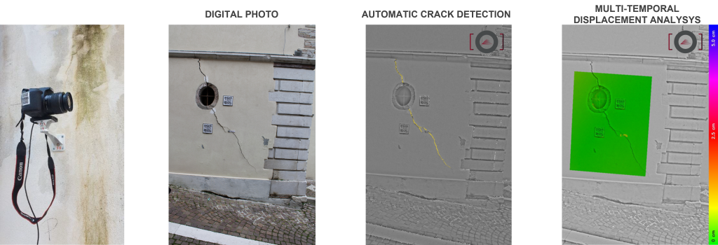
As a result of multi-temporal analysis of optical images, it was possible to assess the deformations of buildings interfering with gravitational slope instability processes, detecting and quantifying the vertical and horizontal components of the displacements that occurred in the scenario in the time interval between 04/02/2022 and 20/11/2022. Furthermore, thanks to the use of pre-installed fixed supports, functional for the repositioning of the camera, it was possible to carry out new acquisitions for the periodic monitoring of the fractures on the selected buildings within the study area
A fundamental role in the alignment, orientation and photographic acquisition operations was played by the CARE software developed by NHAZCA. The software made it possible to orient the camera in real time so that the framing overlaps with that of a previously acquired reference photo through the coupling of singular points. Another decisive programme for this activity was the IRIS software, which allowed the change and displacement analyses of the dataset to be carried out.
The analyses performed were mainly based on the whole monitoring scene, but in order to assess the possible appearance of new lesions, new processing was carried out on the areas affected by the main lesions.